
What a survey and a title search check
Land and records · explainer
A property exists twice: as a physical thing with fences, walls and driveways, and as a legal description recorded in a public office. The two are documented separately, by different professions, and most of the surprises in a transaction live in the gap between them.
The plat and the legal description
Most residential land in a developed area was created by a plat: a recorded drawing that carved a larger tract into numbered lots and blocks, with the streets, alleys and easements shown on it. Once recorded, a property in that subdivision can be described simply by its lot and block within the named plat, which is why so many legal descriptions read as a short string of numbers rather than as a description of anything visible.
Older land, and land never subdivided, is instead described by metes and bounds: a written sequence of bearings and distances that walks the boundary from a defined starting point and returns to it. These descriptions are precise but fragile, because they can depend on physical markers that decay, and because a small error compounds around the perimeter.
What a survey answers
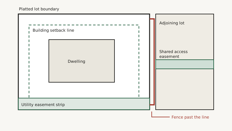
A boundary survey establishes where the recorded lines actually fall on the ground and shows what is standing in relation to them. The drawing it produces typically shows the lot outline, the position of the building, the setback lines that limit where anything may be built, the easements that cross the property, and anything that crosses a boundary in either direction.
The last of these is the one that produces conversations. Fences are built by people, not by surveyors, and a fence that has stood for decades may sit a few feet inside or outside the line. A driveway may cross a corner. A shed may sit partly on a neighbour's ground or partly over an easement. None of these is unusual and none of them is necessarily a problem, but all of them are much easier to address when found before a sale than after.
Setbacks, easements and the difference between them
A setback is a rule about where a structure may stand: a line, usually measured from the boundary, inside which building is permitted. It is a restriction on the owner's own use of their own land, and it is set by whichever authority regulates building in that place.
An easement is different in kind. It is a right held by somebody else over the owner's land, for a defined purpose. A utility easement lets a service provider run and reach its lines. An access easement lets a neighbour cross to reach their own property. A drainage easement keeps a channel clear. The owner still owns the ground, pays tax on it and may often use it, but cannot obstruct the purpose the easement exists for. This is why a shed placed over a utility strip can be required to move years after it was built, and why the question "can I build here?" cannot be answered from the boundary alone.
What a title search answers
A title search examines the recorded history of the property to establish who has the right to convey it and what that conveyance would be subject to. The examination reads backwards through the recorded instruments, building the chain of title: each transfer, each mortgage, each release, each judgment, each restriction, in order.
What it looks for is anything that interrupts the chain or attaches to the property. Common findings include a mortgage that was repaid but never formally released, a lien filed by a contractor, an inheritance where the property passed to several people and not all of them signed, unpaid taxes, or a restriction recorded decades ago that limits what may be done with the land.
These are not usually dramatic. Most are resolved as routine administration. But they are resolved by producing documents, and producing documents takes calendar time, which is the reason title work is begun early rather than treated as a formality at the end.
Recorded restrictions
Separately from public regulation, land can carry private restrictions recorded against it, typically created when a subdivision was laid out. These may govern the type of building permitted, its position, its materials, or the uses to which it may be put, and they run with the land rather than with whoever happened to agree to them.
Two points are worth understanding in general terms. Recorded restrictions and public zoning are independent of each other, so land can be permitted one thing by one and denied it by the other, in which case the stricter governs in practice. And some historic recorded restrictions are unenforceable as a matter of law while still appearing in the records, because striking text out of a recorded instrument is a separate process from ceasing to give it effect.